Acquisition and Management Software for Road Luminance Analysis (EN13201)
Strumenti e funzionalità principali
Our innovative road analysis system, “Street Analysis”, powered by the Street Analysis Evolution software platform, is designed to deliver precise luminance values for any road segment, providing essential data for assessing lighting quality and uniformity in compliance with current European standards (EN13201).
Thanks to its advanced features, users can upload previously captured photo sequences, visualize GPS coordinates (even in tunnels) directly on maps, and analyze key parameters in real time.
The heart of our software lies in its intuitive dashboard, which enables users to capture, upload, and manage image sequences acquired along a road segment or within enclosed environments such as tunnels.
Thanks to this system, the analysis process is greatly streamlined, allowing operators to quickly obtain detailed information for every point within the image.

Dashboard
Intuitive management of luminance acquisitions, with preview visualization and real-time GPS data monitoring of the vehicle. Ideal for operators who require speed and precision in the field.

Map and Coordinate Management:
Display each capture directly on the map
with precise GPS coordinates.
Monitor routes, points of interest,
and distances with high accuracy.

Camera:
Direct control of the LMK or LMK Mobile camera, allowing users to set acquisition parameters and preview luminance images in real time. Ensures optimized measurements under any lighting conditions, regardless of ambient light intensity.

Data Analysis and Reporting
Analysis and comparison of luminance data by lane or road segment, export of customized professional reports, and performance luminance monitoring through dedicated maps and charts.
Dashboard: Complete management of luminance acquisitions
The Dashboard, the core of the Street Analysis Evolution software, is designed to efficiently manage the entire luminance data acquisition process.
The intuitive interface allows users to quickly upload and view image sequences captured along road segments or in tunnels, synchronized with GPS/GNSS data and vehicle information.
The system integrates seamlessly with LMK video photoluminance meters and LMK Mobile cameras, simplifying data collection and reducing processing times. Thanks to real-time previews, operators can immediately monitor lighting conditions, identifying any anomalies or critical points across all road segments or tunnels.
This system is ideal for technicians, infrastructure managers, and industry operators who require a reliable, fast, and precise tool for photometric road monitoring. It is also possible to acquire measurements directly through our services or to rent the various systems.
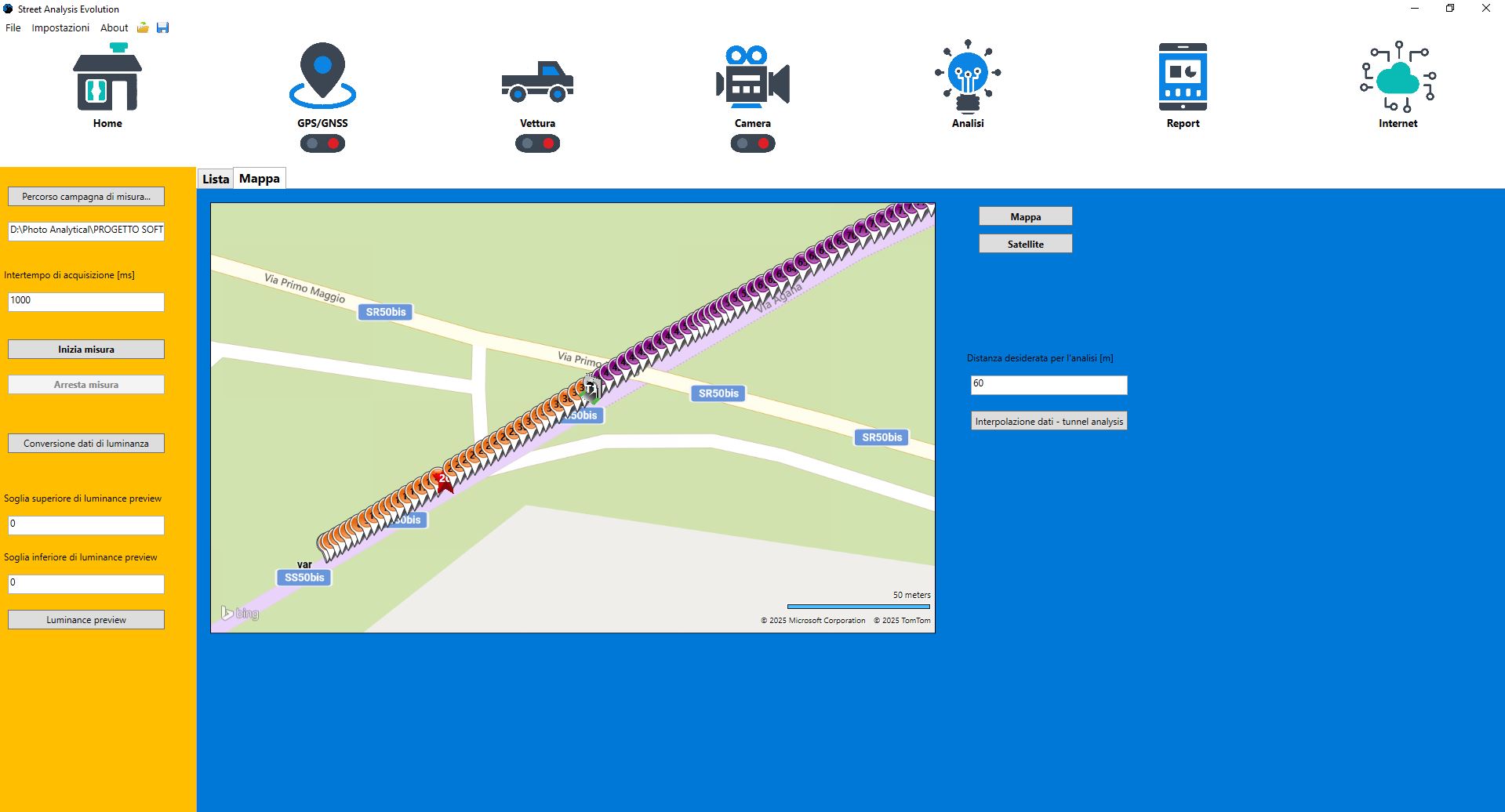
Map: GPS Coordinate Management
The Map and GPS Coordinate Management section allows for real-time visualization of acquisition points, ensuring accurate geographic localization for each capture.
Each image is linked to its GPS/GNSS coordinates, enabling precise positioning on the map and the ability to compare data with points of interest such as tunnels or road intersections.
The software also integrates dynamic interpolation algorithms between positioning data and vehicle movement, providing a comprehensive view of the entire route.
This functionality is essential for photometric street mapping operations and for analyzing lighting efficiency along complex routes or across multiple road or tunnel sequences, without the need to pause measurements between segments.
Camera: advanced control and precision in surveys
The Camera section allows for advanced management of acquisition equipment, such as the LMK Camera and LMK Mobile, ensuring maximum accuracy in luminance measurement.
Operators can set key acquisition parameters—exposure time, focus, use of filters, and calibration—and obtain real-time previews to check for overexposure or measurement errors.
The system provides detailed photometric values for every point in the image, including acquisition speed, accuracy, and type of measurement.
This enables precise operation even under variable lighting conditions, optimizing the process of public and road lighting monitoring.
Data analysis and professional reporting:
In addition to basic image management, the software includes an advanced feature for outlining horizontal road markings and lane demarcations within the portion of the road captured in the photo, allowing for the identification of luminance in specific areas of interest.
This functionality is particularly useful for isolating and analyzing sections quickly and in detail.
Section Outline and AI Integration:
The Data Analysis & Reporting section represents the culmination of the acquisition process.
Here, the software processes luminance images to generate detailed analyses by lane, road segment, or measurement point, displaying graphs, maps, and comparative tables.
Thanks to the “Lanes” and “Luminance Analysis” functions, it is possible to study the distribution of luminance along the road, compare different surveys, and verify compliance with standards (e.g., EN13201).
Results can be exported in Excel (CSV) format or as Word reports, ready for technical documentation or sharing with authorities and clients.
This section provides a comprehensive view of lighting conditions, transforming raw data into actionable and valuable information for maintenance and urban planning.
Important new features:
- Obtain the Luminance Curve by selecting portions of the analyzed areas within the images. Users can define the limits of luminance values of interest. The system automatically recognizes all suitable images in the “Multiple Analysis / Multi-Point Cycle” mode, generating the corresponding curve. The luminance curve can be displayed using a highly intuitive **color scale**, and **graphs and tables** can be generated from the data analysis.
- Calculation of Kerbs / Edges functionality
- It is also possible to analyze additional roadway areas (walls, sidewalks, etc.)
- Currently, integration must be performed manually
- Work is ongoing for automatic calculation and reporting
Practical example of data extraction:
Automatic Line Generation:
Thanks to an integrated artificial intelligence model, the software can automatically generate the lines that delineate the various sections of the roadway. This feature saves time and ensures precise segmentation of the areas to be analyzed.


Manual Tracking:
If you prefer to define sections manually, the software allows you to draw custom lines. Each section can be analyzed separately, facilitating distinction between different areas and enhancing the visual understanding of the data.
Area Parameterization:
For each area, the system performs rectification and determines, according to EN13201 standards, the grid of luminance points required for proper data analysis. This process allows for detailed examination of every section of the road segment and helps identify any anomalies.

The integration of artificial intelligence automates the process of area delineation and also ensures greater accuracy in results, reducing the risk of manual errors and enhancing the overall quality of the analysis.
Key elements of the report:
- Point-by-Point Luminance Values: Depending on the resolution of the camera used for the survey, the software converts each captured pixel into a specific luminance value, allowing for a detailed and localized assessment of light distribution.
- Aggregate Statistics: The report includes maximum (Lmax), minimum (Lmin), and average (Lavg) luminance values for a given area, providing a comprehensive view of luminance along the route.
- Longitudinal and Transversal Uniformity: Measurements such as “lengthwise uniformity,” “overall uniformity,” and “crosswide initial average” help assess how uniform the lighting is along the route and in different directions, which is essential for road safety and visual comfort.
- Interactive and Downloadable Reports: Reports can be viewed directly on the dashboard and downloaded in Word or Excel formats for further analysis, for preliminary documentation, or for integration with other documents. Data can be archived and compared over time, facilitating the planning of maintenance interventions, structural improvements, or inspections. Additional custom reports can be implemented upon user request.

An Innovative Approach to Light Intensity Analysis
Our Street Analysis Evolution system is a cutting-edge tool designed to acquire and analyze luminance at every point of a road segment. With the ability to upload image sequences, an interactive dashboard, advanced automatic delineation features, and a comprehensive reporting system, the software platform provides a complete and detailed overview of outdoor lighting conditions.
The main advantages of our system include:
- Accuracy and Reliability: Real-time, precise data thanks to the integration of advanced technologies and artificial intelligence.
- Operational Efficiency: An intuitive interface that simplifies image management and report generation, reducing the time required for analysis.
- Decision Support: Provided information (Lmax, Lmin, Lavg, longitudinal and transversal uniformity) helps quickly identify potential issues and plan targeted interventions.
- Sustainability and Safety: Optimized energy use and improved road safety through accurate analysis and continuous evaluation of lighting.
If your goal is to ensure proper public lighting, test lighting systems, enhance safety, and improve energy efficiency, our Street Analysis Evolution system is the perfect tool for you. Contact us today for a free demonstration and discover how we can help you transform the way you monitor and manage street and tunnel lighting!